
Flight Routes, Shipping Routes, Under Sea Cables
IFERS - Exposing the 'Global' Conspiracy From Atlantis to Zion :: The International Flat Earth Research Society
Page 2 of 5 •  1, 2, 3, 4, 5
 ![]()
Re: Flight Routes, Shipping Routes, Under Sea Cables
![]() by lizardking Sun Jan 17, 2016 9:25 pm
by lizardking Sun Jan 17, 2016 9:25 pm
"As of April 1, 2015, the longest non-stop scheduled airline flight is Qantas Flight from Dallas-Fort Worth, USA to Sydney, Australia."
13,804 km (8,577 miles)
These long haul flights, between diversion airfields, use aircraft not subject to ETOPS restrictions.
"Engines Turn Or Passengers Swim"

lizardking- Posts : 1673
Points : 7388
Reputation : 2604
Join date : 2015-12-30
Age : 30
Location : United Kingdom
Re: Flight Routes, Shipping Routes, Under Sea Cables
![]() by lizardking Sun Jan 17, 2016 9:25 pm
by lizardking Sun Jan 17, 2016 9:25 pm
I find it much easier when finding the answers to my questions and building up a repertoire of arguments to look outside the realm of related FE Google searches and look for problems that the ball model has on people's perceptions. I assume everyone is aware that flight dynamics works on a FE model so I won't go into that (I can provide links if anyone wants) suffice to say that we can't blame pilots for covering anything up when in fact they are trained to work on an FE model for simplicity. But I began thinking, 'What about flight sim players?' After all they're not trained pilots and wouldn't have had the dynamics forced upon them. What happens when they try to fly over Antarctica or go pole to pole? I found the results both hilarious and startling.
For example (I had to read this twice) here is the official description for the Antarctica X add on for Aerosoft's flight sim. "Oh you want a flight sim over Antarctica? Don't think so. Here's some paper maps. Fill it in best you can. Bye."
en.shop.aerosoft.com/eshop.php?action=article_detail&s_supplier_aid=12123&s_design=DEFAULT&shopfilter_category=Flight+Simulation&s_language=english
Now when you look at the sim forums you find people trying to fly over either pole and experiencing problems. The solution to which is the explanation that the sims also operate on an FE model and this causes glitches when you try to pole fly. Oh really?
Look at these.
forum.aerosoft.com/index.php?/topic/52893-ice-wall-artifact-in-antarctica/
Note that in the comments the wall extends from horizon to horizon.
www.flightsim.com/vbfs/showthread.php?25633-Flight-over-Antarctica&s=bd70940eff02b1d7aa3d6e60380d527a
forum.flyawaysimulation.com/forum/topic/1363/can-not-reach-north-pole-in-fs2004-fs9/
www.flightsim.com/vbfs/showthread.php?205322-AI-aircraft-and-Antarctica
I'm sure you can find more. That took me five minutes. But it's interesting that a ball model will not work for flight sims.
On another note here is an abstract from a book about the psychology of children and what happened when they put them in a flight sim. It accords with my post about the education paradigm. Note how the belief of your observation is basically brainwashed out of you as a child (scroll down for diagram showing how your perception is changed through grade years). If this link doesn't work find the book on Google books and search:Learn Psychology by Kenneth Carter and search flat earth within.
[url=https://books.google.co.uk/books?id=KkZyfw6Vqc4C&q=flat+earth#v=snippet&q=flat earth&f=false][/url][url=https://books.google.co.uk/books?id=KkZyfw6Vqc4C&q=flat+earth#v=snippet&q=flat earth&f=false]books.google.co.uk/books?id=KkZyfw6Vqc4C&q=flat+earth#v=snippet&q=flat%20earth&f=false[/url]
lizardking- Posts : 1673
Points : 7388
Reputation : 2604
Join date : 2015-12-30
Age : 30
Location : United Kingdom
Re: Flight Routes, Shipping Routes, Under Sea Cables
![]() by lizardking Sun Jan 17, 2016 9:26 pm
by lizardking Sun Jan 17, 2016 9:26 pm
it seems like every other day there is more and more (dis)information being posted, which, to me, seems like an attempt to deter the many awakening FE's;
www.bloomberg.com/news/articles/2015-08-13/emirates-to-grab-longest-flight-title-with-panama-route
lizardking- Posts : 1673
Points : 7388
Reputation : 2604
Join date : 2015-12-30
Age : 30
Location : United Kingdom
Re: Flight Routes, Shipping Routes, Under Sea Cables
![]() by lizardking Sun Jan 17, 2016 9:26 pm
by lizardking Sun Jan 17, 2016 9:26 pm
"On another note here is an abstract from a book about the psychology of children and what happened when they put them in a flight sim. It accords with my post about the education paradigm. Note how the belief of your observation is basically brainwashed out of you as a child (scroll down for diagram showing how your perception is changed through grade years). If this link doesn't work find the book on Google books and search:Learn Psychology by Kenneth Carter and search flat earth within.
books.google.co.uk/books?id=KkZyfw6Vqc4C&q=flat+earth#v=snippet&q=flat%20earth&f=false"
This page is blocked when you first land:
I get this message: "Restricted Page- You have reached your viewing limit for this book (why?)."
However if you click the page number forward, then go back to page 463 you can read it.
That book lead me to the information below, thank you... another gold mine.
lizardking- Posts : 1673
Points : 7388
Reputation : 2604
Join date : 2015-12-30
Age : 30
Location : United Kingdom
Re: Flight Routes, Shipping Routes, Under Sea Cables
![]() by lizardking Sun Jan 17, 2016 9:26 pm
by lizardking Sun Jan 17, 2016 9:26 pm
Study on cognitive restructuring of astronomy in children:
files.eric.ed.gov/fulltext/ED404098.pdf <-- Vosniadou & Brewer 1972
Studies on convincing children not to believe their eyes:
www.researchgate.net/publication/3208810_The_Round_Earth_Project-collaborative_VR_for_conceptual_learning
"For example, different viewpoints contribute to multiple representations in Bakas and Mikropoulos (2003) by allowing students to observe planetary phenomena from spaceship and Sun. In Johnson et al. (1999) each child acts both as an astronaut and mission control during the interaction with the EVE to see both views in order to understand that the Earth is spherical and the implications of that fact. In NewtonWorld (Dede et al., 1999), students can change their viewpoint by becoming a ball moving along the corridor or an observer thus providing multiple representations of the phenomena under study. "
EVE = 'Educational Virtual Environments'
www.researchgate.net/publication/223735649_Educational_virtual_environments_A_ten-year_review_of_empirical_research_%2819992009%29
www.researchgate.net/publication/220374385_A_Desktop_Virtual_Reality_Earth_Motion_System_in_Astronomy_Education
lizardking- Posts : 1673
Points : 7388
Reputation : 2604
Join date : 2015-12-30
Age : 30
Location : United Kingdom
Re: Flight Routes, Shipping Routes, Under Sea Cables
![]() by lizardking Mon Jan 18, 2016 10:17 pm
by lizardking Mon Jan 18, 2016 10:17 pm
susie,
Great pic. I was talking to a young lady the other day that claimed the earth is a ball because she flew in a circle around the earth in her rich dad's jet. There was simply no convincing her and she started resorting to theoretical physics formulas. After not being able to answer any of my questions, she finally sent me a picture of Putin on a great white shark while simultaneously calling me a retard and then blocked me before I could reply, haha.
lizardking- Posts : 1673
Points : 7388
Reputation : 2604
Join date : 2015-12-30
Age : 30
Location : United Kingdom
CockneyChristi1 likes this post
Re: Flight Routes, Shipping Routes, Under Sea Cables
![]() by lizardking Mon Jan 18, 2016 10:17 pm
by lizardking Mon Jan 18, 2016 10:17 pm
Sept 21, 2015 18:03:16 GMT planearth said:
Study on cognitive restructuring of astronomy in children:
files.eric.ed.gov/fulltext/ED404098.pdf <-- Vosniadou & Brewer 1972
Abstract
"curricula requires the restructuring of prior knowledge,"
"particular attention must be paid to scientific concepts,"
"that compromise the students everyday experience."
Only on the Magical Ball Earth does Theory pass for Science.
lizardking- Posts : 1673
Points : 7388
Reputation : 2604
Join date : 2015-12-30
Age : 30
Location : United Kingdom
Re: Flight Routes, Shipping Routes, Under Sea Cables
![]() by Schpankme Mon Mar 14, 2016 6:42 am
by Schpankme Mon Mar 14, 2016 6:42 am
New - 2016
Emirates Flight (EK449) from Auckland - to - Dubai
14,203 km (8,825 mi) .. 17 hr 15 min
Old - 2015
Qantas Flight (QF8) from Dallas-Fort Worth, USA - to - Sydney, Australia
13,804 km (8,578 mi) .. 16 hr 55 min
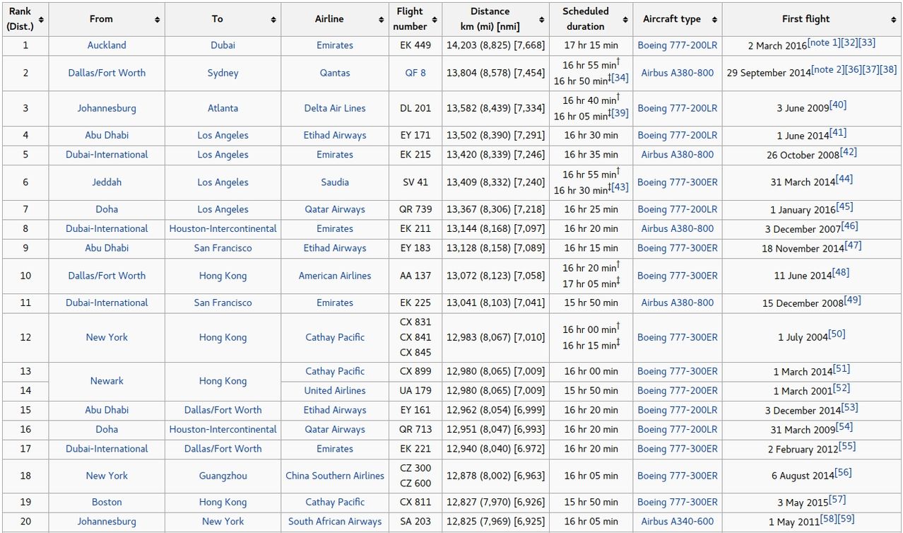
Here is the Top 20 longest Flight in order of Distance:
Note, there are NO Flights from South America to Australia/New Zealand.
† Summer schedule (northern hemisphere; austral winter)
‡ Winter schedule (northern hemisphere; austral summer)

Schpankme- Posts : 1202
Points : 5869
Reputation : 1606
Join date : 2015-12-30
FLIGHT ADVISORY GPS Interference Testing CHLK GPS 16-08 07-30 June, 2016 China Lake, California
![]() by californian Tue Jun 07, 2016 11:07 pm
by californian Tue Jun 07, 2016 11:07 pm
In other words, if GPS signals are being interfered with above 50 feet, and they claim that GPS information is sent to/from satellites in "outer space", how is that GPS information made coherent again back down at ground level..?! I do not see how that is possible.
What makes sense is that GPS information is ground-based (triangulated like cell phone technology), and these tests are being done to scramble that ground based information for aircraft while leaving low altitude use of GPS signals unaffected.
http://www.zerohedge.com/news/2016-06-07/mysterious-military-tests-may-lead-widespread-west-coast-gps-disruptions-faa-warns
https://www.faasafety.gov/files/notices/2016/Jun/CHLK_16-08_GPS_Flight_Advisory.pdf
californian- Posts : 1
Points : 2988
Reputation : 0
Join date : 2016-02-21
Re: Flight Routes, Shipping Routes, Under Sea Cables
![]() by Schpankme Tue Jun 07, 2016 11:37 pm
by Schpankme Tue Jun 07, 2016 11:37 pm
californian wrote:
military test going on in California that will affect GPS systems
the breadth of the interference is altitude dependent.
Here's another related GPS story from 2015
3 weeks of Red Flag exercises, GPS interference testing begin; Southern Nevada
This test is related to "Broadcasting Down" from specific altitudes, according to the advisory
Above Ground Testing (disruption):
50 feet = 206 nautical miles
25,000 feet = 366 nautical miles
Note, that increasing the altitude of the Aircraft doing the Disrupting, from 50 feet to 25,000 feet, only increased the effected area by 160 nautical miles.
What this means, is that one CELL TOWER could be used to disrupt the majority of Mobile Phones (GPS), within a 200 nautical mile radius, each phone then broadcasting the signal to it's nearest neighbor (i.e. virus).

Welcome to the flat Earth.
Schpankme- Posts : 1202
Points : 5869
Reputation : 1606
Join date : 2015-12-30
Re: Flight Routes, Shipping Routes, Under Sea Cables
![]() by feblogger Wed Jun 15, 2016 2:07 am
by feblogger Wed Jun 15, 2016 2:07 am
I did this research yesterday. This site lists a direct flight Auckland NZ to Buenos Aries AR, almost daily, on Jun 14:
https://flightbookings.airnewzealand.co.nz/vbook/actions/selectitinerary
and the snapshot:
https://2img.net/h/s32.postimg.cc/iikp5msd1/fe_auckland_buenos_aries_booking.png
The flight is on Tue Jun 14 at 8.05pm NZ time. But, there is no flight number, so I went to the airport's site to find it.
https://www.aucklandairport.co.nz/flights
and the snapshot:
https://2img.net/h/s32.postimg.cc/yozvum80l/fe_auckland_buenos_aries_departures.png
the flight is not listed at departures at all... Apparently it doesn't exist
Then I found the LAN801 Santiago to Auckland, which I started tracking successfully on the flightradar24, but it disappeared just 1h 35 mins in flight, as soon as it left Chile.
here is the snapshot at the moment of the "disappearance"
https://2img.net/h/s31.postimg.cc/kcdsiau63/fe_lan801_santiago_auckland_map_disappeared.png
I waited 11 hours for the of arrival (I went to sleep), and the flightradar24 still couldn't show the plane. I then went to the Auckland airport site arrivals, and found the flight was "RESCHEDULED" from 5.05AM to 8:40PM, ie delayed the whole 15h and 35m. The flight departed on time with scheduled 12h 50m flight time, and with this "delay" of 15h 35m, the flight time becomes 29 hours
here is the snap:
https://2img.net/h/s32.postimg.cc/ttickwied/fe_lan801_santiago_auckland_rescheduled.png
In the same time, this flightaware.com site
https://flightaware.com/live/flight/LAN801
reports everything was fine and the plane was in fact scheduled to land in 1h 30m (?).
Here is the snap:
https://2img.net/h/s31.postimg.cc/k15zgmu2j/fe_lan801_santiago_auckland_flightaware.png
And the parody continues, the site flightexplorer.com reports the LA801 in fact arrived at Auckland at 8.42am with "NO DELAY" (while the airport, as I said above, reports it is "RESCHEDULED", and delayed 15h and 35m!)
http://travel.flightexplorer.com/trackFlight.aspx
and the snap:
https://2img.net/h/s31.postimg.cc/q7anetj2z/fe_lan801_santiago_auckland_flightexplorer.png
And finally, I looked at the flightradar24 at the LA801 history, and saw that the flight has *always* landed around 5pm (scheduled 5am), that is with the 12+ hours delay, which makes the flight time of 24+ hours (if it exists at all):
https://www.flightradar24.com/data/flights/la801/
and the snap
https://2img.net/h/s31.postimg.cc/a9t1frg7v/fe_lan801_santiago_auckland_flightradar24_histor.png
so, I guess the case is closed.
QED
feblogger- Posts : 2
Points : 2885
Reputation : 3
Join date : 2016-06-07
Re: Flight Routes, Shipping Routes, Under Sea Cables
![]() by csp Wed Jun 15, 2016 5:20 am
by csp Wed Jun 15, 2016 5:20 am
feblogger wrote:so, I guess the case is closed.
Correct, all fraudulent flights - a different LAN flight I investigated previously showed the plane registration servicing the SYD->DALLAS->SANTIAGO route (which was tracked properly on FR24,FT, etc), while at the same time being used for the fake SYD->SANTIAGO route.

csp- Posts : 424
Points : 4515
Reputation : 1054
Join date : 2016-01-04
Location : Australia
Re: Flight Routes, Shipping Routes, Under Sea Cables
![]() by Beashambassador Sat Jun 25, 2016 11:20 pm
by Beashambassador Sat Jun 25, 2016 11:20 pm
sanje wrote:Hi everybody this is my first post.
I'm aware of the earth is flat, but im trying to be very strict to have the strongest evidence in every way possible, therefore I just did a research throughout the web about direct flights from Auckland to Santiago.
I always found two companies that claim to have direct flights for this route.
Qantas airlines, for example:
18.00-14.15 AKL-SCL (12h 15m)
01.05-05.15+1 SCL-AKL (12h 10m)
and
LATAM airlines group with the same timing.
Has anyone tracked this airlines companies and this routes?
Apparently the spinning of the ball doesn't affect the time of flight, the return trip takes the same time, they are not worry about it but they should.
I found it arrogant because they feel very confident about this lie that they dont find reasons to try make this Bullshits more trustable.
I have read many official sources and apparently the "science" admit that the spinning doesn't affect the time but no one explain why.
Welcome aboard IFERS sanje, hope this answers your question, Best regards
Re: Flight Routes, Shipping Routes, Under Sea Cables
Post by Schpankme on Mon Mar 14, 2016 1:42 am
As of March 1, 2016 the longest scheduled flight route has changed:
New - 2016
Emirates Flight (EK449) from Auckland - to - Dubai
14,203 km (8,825 mi) .. 17 hr 15 min
Old - 2015
Qantas Flight (QF8) from Dallas-Fort Worth, USA - to - Sydney, Australia
13,804 km (8,578 mi) .. 16 hr 55 min
Here is the Top 20 longest Flight in order of Distance:
Note, there are NO Flights from South America to Australia/New Zealand.
For more detail see Schpankme IFERS posting above

Beashambassador- Posts : 111
Points : 3444
Reputation : 306
Join date : 2016-01-12
Age : 78
Location : USA
Re: Flight Routes, Shipping Routes, Under Sea Cables
![]() by feblogger Fri Jul 01, 2016 1:36 am
by feblogger Fri Jul 01, 2016 1:36 am
The site reports that it took off at 1.21am CLT (scheduled 12:55am, so late at departure 26mins), and arrived at 4:59am NZST ( scheduled for 2:46am, so late at arrival 2h 13min). In all they say the flight took 12h 38m
Now this is the interesting parth. The site also reports the averages. The average departure is 1.33am CLT, but, the average arrival is 9.11PM NZST, and with this average arrival the average flight is 27h 37m !!! (This flight came 15h earlier than the average time, ie 50+% earlier. And the official expected time of the flight is 50% of the average time...)
That corresponds perfectly with my previous post when the flight was "rescheduled" for 15h or so
Interesting
https://2img.net/h/s32.postimg.cc/v25oi5qsl/flightaware_lan801_average.png
feblogger- Posts : 2
Points : 2885
Reputation : 3
Join date : 2016-06-07
Re: Flight Routes, Shipping Routes, Under Sea Cables
![]() by Schpankme Mon Oct 10, 2016 7:56 am
by Schpankme Mon Oct 10, 2016 7:56 am
"Interactively explore the coastal views of international waterfronts"
aka GOOGLE TREKKER
Last edited by Schpankme on Tue Jan 24, 2017 10:39 pm; edited 1 time in total
Schpankme- Posts : 1202
Points : 5869
Reputation : 1606
Join date : 2015-12-30
Re: Flight Routes, Shipping Routes, Under Sea Cables
![]() by inerratic Wed Oct 12, 2016 12:07 am
by inerratic Wed Oct 12, 2016 12:07 am

inerratic- Posts : 59
Points : 2927
Reputation : 41
Join date : 2016-08-02
Location : Austin, Texas
Re: Flight Routes, Shipping Routes, Under Sea Cables
![]() by FL@T-E@RTH Thu Oct 20, 2016 7:07 pm
by FL@T-E@RTH Thu Oct 20, 2016 7:07 pm
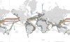
95% of Global Internet & Telecommunications traffic is delivered under sea via fibre optic cables, (click thumbnail above) just the TAT-14 cable that links Denmark, Germany, Netherlands, France, UK & USA has a design capacity of 9.4 TERRABITS a second with 3.2 TERRABITS currently 'lit' (in use) and there are more than 16 of these cables connecting Europe to the USA.
The other 5% of Internet/Telecommunications is delivered over the old phone-line network (copper cable using ADSL for Internet) and of course land based cell towers.
With the explosion of mobile/cell phones and mobile Internet the amount of cell towers needed to grow exponentially.
So was born the need for more and more towers, however if they started popping up everywhere people would ask the question "Why do we need this many towers if we have satellites?"
So they came up with a truly cunning plan, the Digital TV Switch-over which is currently being done Worldwide, most countries are already switched over to Digital leaving just the following countries:
2016: Mexico, Mongolia, Laos, Ukraine, Chile,
2017: Bolivia, Colombia, Paraguay, Peru, Sri Lanka and Indonesia
2018: Brazil Costa Rica, Moldova and El Salvador
2019: Argentina, Russia and Thailand
2020: Panama, Philippines, Hong Kong, Venezuela and Vietnam
2021: Cuba and Dominican Republic
INTERESTINGLY the only country not to switch-over will be North Korea (that warrants a smiley)
But what the hell does the Digital TV switch-over have to do with there being no satellites you may ask.
Well, the analogue TV transmitters provide on average 99% geographical coverage of the countries in which they are based.
By changing the TV transmitters to Digital means they automatically become a HUGE wi-fi Network with insane capacity.
As an example:
In the UK the TV Transmitters use the frequency's from 450mhz to 800mhz and above 800mhz is used for 4G services.
When you consider using QAM256 transmission mode you can cram 40Mbps in to EVERY 8mhz of analogue bandwidth.
That is almost a 2 GIGABIT a second wi-fi network without taking in to account the 4G bandwidth which can use 20mhz bands to obtain a data rate of 172Mbps for each band.
And 4G uses the following frequency's, 800mhz, 900mhz 1800mhz, 2100mhz, 2400mhz, 2600mhz
You don't need to be a mathematician to see how big this wi-fi Network is.
Why are we relying on the TV transmitters and the Digital TV switch-over to create such a huge wi-fi communication network?
BECAUSE SATELLITES DO NOT EXIST
Addendum *
The Digital TV switch-over which facilitated this huge wi-fi network will be the backbone of the SMART grid which is something to look into if you are not aware of this.

FL@T-E@RTH- Posts : 216
Points : 3259
Reputation : 268
Join date : 2016-10-12
Age : 51
Location : Certainly Not On A Globe
Re: Flight Routes, Shipping Routes, Under Sea Cables
![]() by inerratic Thu Oct 20, 2016 11:06 pm
by inerratic Thu Oct 20, 2016 11:06 pm
inerratic- Posts : 59
Points : 2927
Reputation : 41
Join date : 2016-08-02
Location : Austin, Texas
Re: Flight Routes, Shipping Routes, Under Sea Cables
![]() by csp Thu Oct 20, 2016 11:53 pm
by csp Thu Oct 20, 2016 11:53 pm
inerratic wrote:Thanks for that. Do you have any info on why the cell towers, with the extra large cables, going to toothbrush box proportioned transmitters are popping up everywhere in the States? About every 3 miles in some areas.
More accurate triangulation, easier for the state to track dissidents.
If I were a truther in the US, I'd personally stay off the mobile networks and use TOR or a reliable non-US based VPN service for all internet access.
csp- Posts : 424
Points : 4515
Reputation : 1054
Join date : 2016-01-04
Location : Australia
Re: Flight Routes, Shipping Routes, Under Sea Cables
![]() by FL@T-E@RTH Fri Oct 21, 2016 12:04 am
by FL@T-E@RTH Fri Oct 21, 2016 12:04 am
inerratic wrote:Thanks for that. Do you have any info on why the cell towers, with the extra large cables, going to toothbrush box proportioned transmitters are popping up everywhere in the States? About every 3 miles in some areas.
I am sorry my friend, I have no idea what is occurring in the US with regards to the cell towers.
I would hazard a guess that they are most likely to do with the SMART grid and SMART meters,
I am aware the US is much further along with the roll-out of SMART meters,
We are only just seeing them being rolled out in the UK at present (with the lure of 'free' weekend electricity if you accept these SMART meters).
I do know that AT&T Mobility & Verizon Wireless sold a lot of their towers to American Tower & Crown Castle last year. So something is obviously afoot.
I will do some thorough research and report my findings!
FL@T-E@RTH- Posts : 216
Points : 3259
Reputation : 268
Join date : 2016-10-12
Age : 51
Location : Certainly Not On A Globe
Re: Flight Routes, Shipping Routes, Under Sea Cables
![]() by FL@T-E@RTH Sun Oct 23, 2016 12:06 pm
by FL@T-E@RTH Sun Oct 23, 2016 12:06 pm
US telecoms giant AT&T has announced that it will buy entertainment group Time Warner for nearly $86bn (£70bn).
The deal - one of the biggest this year - still needs approval from regulators.
If the takeover goes through, it would combine AT&T's distribution network with content from the Warner Brothers film studios and the cable TV channels HBO and CNN.
AT&T's chairman described it as "a perfect match" but critics say it concentrates too much media power.
The deal is likely to be closely scrutinised by US antitrust regulators. AT&T is already the third largest cable TV provider in the US.
Randall Stephenson, who is both chairman and CEO of AT&T, said he did not anticipate any regulatory obstacles, saying any concerns could be overcome if concessions were made.
"This is a perfect match of two companies with complementary strengths who can bring a fresh approach to how the media and communications industry works for customers, content creators, distributors and advertisers," he said.
An AT&T statement said that aim of the deal was to give customers "unmatched choice, quality, value and experiences that will define the future of media and communications"
FL@T-E@RTH- Posts : 216
Points : 3259
Reputation : 268
Join date : 2016-10-12
Age : 51
Location : Certainly Not On A Globe
Re: Flight Routes, Shipping Routes, Under Sea Cables
![]() by FL@T-E@RTH Mon Oct 24, 2016 6:16 am
by FL@T-E@RTH Mon Oct 24, 2016 6:16 am
inerratic wrote:Thanks for that. Do you have any info on why the cell towers, with the extra large cables, going to toothbrush box proportioned transmitters are popping up everywhere in the States? About every 3 miles in some areas.
I spoke to a lifelong friend who worked for Vodafone in the UK till 2002,
He states the transmitters you are seeing every 3 miles are 4G cell towers, these 4G cell towers are transmitting at:
824-851mhz - Cellular A & B franchises, terminal
869-896mhz - Cellular A & B franchises, base station
1575mhz - GNSS L1 band—GPS (funny that, I thought GPS was done by satellite lol)
1710-1755mhz - AWS mobile phone uplink (UL) operating band
1850–1910mhz - PCS mobile phone (3 blocks at 15mhz and 3 blocks at 5mhz)
1930–1990mhz - PCS base stations (3 blocks at 15mhz and 3 blocks at 5mhz)
2110–2155mhz - AWS mobile phone downlink (DL) operating band
The higher the frequency the smaller area they cover due to interference, (trees/hills/buildings etc) hence the need for towers every few miles. It's called a wireless mesh network.
Think of wi-fi in your home, it has a very small range, (say 30metres) wi-fi uses 2400mhz, now the transmitters in your router are not as powerful as the cell towers, but it is the same principle.
FL@T-E@RTH- Posts : 216
Points : 3259
Reputation : 268
Join date : 2016-10-12
Age : 51
Location : Certainly Not On A Globe
Re: Flight Routes, Shipping Routes, Under Sea Cables
![]() by inerratic Thu Nov 17, 2016 9:37 pm
by inerratic Thu Nov 17, 2016 9:37 pm
inerratic- Posts : 59
Points : 2927
Reputation : 41
Join date : 2016-08-02
Location : Austin, Texas
Re: Flight Routes, Shipping Routes, Under Sea Cables
![]() by Bobby Peru Wed Feb 15, 2017 1:17 pm
by Bobby Peru Wed Feb 15, 2017 1:17 pm
news article of worlds biggest plane landing in Norway because of someone needing medical attention .....ABU DHABI TO NEW YORK
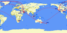
globe vs FE map routes https://imgur.com/a/a8iCY


Bobby Peru- Posts : 7
Points : 2805
Reputation : 5
Join date : 2016-09-03
Re: Flight Routes, Shipping Routes, Under Sea Cables
![]() by blackchoy Sun Feb 19, 2017 5:08 pm
by blackchoy Sun Feb 19, 2017 5:08 pm
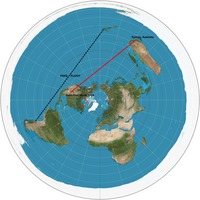
I'm looking at flights recently to plan a trip maybe later this year and I was curious what the flight would look like if it was on the flat earth. Using a recent high-resolution Gleason map shared by a user in the Flat Earth Maps topic, I plotted some points.
The red line is the direct flight path from NYC to Hong Kong. I plotted some blue dots which are approximate locations of certain landmasses or cities based on my estimates from the Google flight map. Note the cities Yakutsk, Russia and Beijing, China. Very close to the red line indeed! Maybe next time I go, I can collect some more information through the flight tracker feature.
https://www.dropbox.com/s/y7j7zinibukltbr/nyc_hkg%20flat%20map.png?dl=0
https://www.dropbox.com/s/bmw05s0yvmnps14/nyc_hkg%20flight.png?dl=0
Last edited by blackchoy on Sat Apr 22, 2017 3:16 pm; edited 2 times in total
blackchoy- Posts : 12
Points : 2645
Reputation : 10
Join date : 2017-02-19
Page 2 of 5 • 1, 2, 3, 4, 5 ![]()
IFERS - Exposing the 'Global' Conspiracy From Atlantis to Zion :: The International Flat Earth Research Society
|
|
|